Tag: data collection

A kludge to build a rental registry in Cook County 

Chicago should have a rental registry, a database of dwelling units that are rented to tenants, for at least two reasons:

  1. The city can know things about the rental units, including how much they cost, where they are, and if any are vacant and could be occupied if only people knew they were available and how to get in touch with the owner.
  2. The city can know who the owners are and contact them to issue citations or advise them, or fill out for them, emergency rental assistance during pandemics and other times of necessity.

Building and administering a rental registry from scratch would be very expensive – probably tens of millions to start and more than one million annually.

I propose a kludge that uses existing databases and modifies existing standard operating procedures amongst a small group of Cook County and Chicago agencies. A kludge is a workaround. It has other meanings and an uncertain etymology.

An ideal rental registry helps solve at least four problems:

  1. Identify who owns a rental home
  2. The number of rental units are in a building
  3. Rental price
  4. Rental unit availability [see my other blog post about counting vacant units]
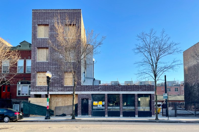
A 9-unit apartment building in Little Italy is undergoing renovation.

The kludge has four parts

1. Incorporate data about the number of units declared on Real Estate Transfer Tax forms (which in Cook and many other counties are transmitted to the Illinois Department of Revenue digitally).

There is already a city office that reviews or audits these forms looking for instances where the buyer or seller incorrectly claimed certain exemptions from RETT, because of how the city can lose revenue. That office can also enforce that the number of units was correctly entered on the form. 

2. For banks that hold city deposits, amend legislation to require that their newly issued or refinanced mortgages specify the number of units in the required submitted documentation. The ordinance that regulates banks that hold city deposits was amended a few years ago to require that they report how many loans they issue in Chicago for both commercial and residential properties.

Databases 1 and 2 are checks for each other. 

3. “Hire” the Cook County Assessor’s Office to create and operate the database for the unit count data from 1 and 2 (likely as an augmentation of their existing database).

The database would also store any data the CCAO collects through the commercial valuation data they obtain from third party sources as well as from the owners who volunteer it (Assessor Kaegi is already collecting and publicly publishing this information). 

At this point, with features 1, 2, and 3, we are assembling a pretty broad but incomplete record of where rental units are. It will be come more complete over time as properties transfer (sell) and the details of the transfer (sale), and the properties themselves, are recorded.

It doesn’t have a clue as to the rental prices

4. The Cook County Assessor’s Office creates new property classifications. Property classifications allow for the comparison of like buildings for the purpose of establishing assessed values for all properties that are not tax exempt.

One of the most common classifications in Chicago is “2-11”, for apartment buildings with two to six units. This means that, generally, the value of the ubiquitous two-flats and three-flats get compared to other each other and sometimes to four-flats, etc.

I suggest that there should be a few new property classifications, but I have only one idea so far: classify limited equity and Chicago Housing Trust properties differently. 

Bickerdike is one organization that built a lot of limited equity row houses and detached houses in the 1990s and 2000s but I am not aware of a publicly accessible database identifying them.

These houses represent permanently affordable housing and we should have a better system to track them!

This screenshot of part of a spreadsheet is the apartments data that the Cook County Assessor’s Office collected for the 2021 tax year. 

How broad is the kludge?

  • Using the Real Estate Transfer Tax data from 2022 Q1 to Q3, there were 3,550 buildings in Chicago having 22,217 units transferred. (I don’t know how many were arms length transactions, meaning they were sold to new owners.)
  • In the CCAO’s apartments data collected for the Rogers Park Township, there is semi-detailed information about 715 buildings that have seven or more apartments comprising 18,541 units. Details include the unit size breakdown by bedroom count.

Chicago has 556,099 rented dwelling units in buildings with two or more units (according to the ACS 2021 1-year estimate). In my limited analysis I’ve already found data about 7.4 percent of them, and that’s only for part of the city [1].

Notes, limitations, and updates

[1] There may also be duplicates between the buildings in the RETT database and the CCAO apartments dataset.

These databases would not have information about detached (“single family”), single-unit semi-detached (rowhouses and townhouses), and condos used as rentals. This severely limits the coverage of information. As it stands, Chicago Cityscape has data coverage of unit count information for about 37 percent of multi-family (apartment) buildings.

5th Ward Alderperson Desmond Yancy proposed an ordinance that would establish a rental registry (O2023-0004085). The rationale for such is shown in the screenshot below. (Go directly to the ordinance’s PDF.)

Screenshot of the proposed rental registry benefits.

Working with ZIP code data (and alternatives to using sketchy ZIP code data)

1711 North Kimball Avenue, built 1890

This building at 1711 N Kimball no longer receives mail and the local mail carrier would mark it as vacant. After a minimum length of time the address will appear in the United States Postal Service’s vacancy dataset, provided by the federal Department of Housing and Urban Development. Photo: Gabriel X. Michael.

Working with accurate ZIP code data in your geographic publication (website or report) or demographic analysis can be problematic. The most accurate dataset – perhaps the only one that could be called reliably accurate – is one that you purchase from one of the United States Postal Service’s (USPS) authorized resellers. If you want to skip the introduction on what ZIP codes really represent, jump to “ZIP-code related datasets”.

Understanding what ZIP codes are

In other words the post office’s ZIP code data, which they use to deliver mail and not to locate people like your publication or analysis, is not free. It is also, unbeknownst to many, a dataset that lists mail carrier routes. It’s not a boundary or polygon, although many of the authorized resellers transform it into a boundary so buyers can geocode the location of their customers (retail companies might use this for customer tracking and profiling, and petition-creating websites for determining your elected officials).

The Census Bureau has its own issues using ZIP code data. For one, the ZIP code data changes as routes change and as delivery points change. Census boundaries needs to stay somewhat constant to be able to compare geographies over time, and Census tracts stay the same for a period of 10 years (between the decennial surveys).

Understanding that ZIP codes are well known (everybody has one and everybody knows theirs) and that it would be useful to present data on that level, the Bureau created “ZIP Code Tabulation Areas” (ZCTA) for the 2000 Census. They’re a collection of Census tracts that resemble a ZIP code’s area (they also often share the same 5-digit identifiers). The ZCTA and an area representing a ZIP code have a lot of overlap and can share much of the same space. ZCTA data is freely downloadable from the Census Bureau’s TIGER shapefiles website.

There’s a good discussion about what ZIP codes are and aren’t on the GIS StackExchange.

Chicago example of the problem

Here’s a real world example of the kinds of problems that ZIP code data availability and comprehension: Those working on the Chicago Health Atlas have run into this problem where they were using two different datasets: ZCTA from the Census Bureau and ZIP codes as prepared by the City of Chicago and published on their open data portal. Their solution, which is really a stopgap measure and needs further review not just by those involved in the app but by a diverse group of data experts, was to add a disclaimer that they use ZCTAs instead of the USPS’s ZIP code data.

ZIP-code related datasets

Fast forward to why I’m telling you all of this: The U.S. Department of Housing and Urban Development (HUD) has two ZIP-code based datasets that may prove useful to mappers and researchers.

1. ZIP code crosswalk files

This is a collection of eight datasets that link a level of Census geography to ZIP codes (and the reverse). The most useful to me is ZIP to Census tract. This dataset tells you in which ZIP code a Census tract lies (including if it spans multiple ZIP codes). HUD is using data from the USPS to create this.

The dataset is documented well on their website and updated quarterly, going back to 2010. The most recent file comes as a 12 MB Excel spreadsheet.

2. Vacant addresses

The USPS employs thousands of mail carriers to delivery things to the millions of households across the country, and they keep track of when the mail carrier cannot delivery something because no one lives in the apartment or house anymore. The address vacancy data tells you the following characteristics at the Census tract level:

  • total number of addresses the USPS knows about
  • number of addresses on urban routes to which the mail carrier hasn’t been able to delivery for 90 days and longer
  • “no-stat” addresses: undeliverable rural addresses, places under construction, urban addresses unlikely to be active

You must register to download the vacant addresses data and be a governmental entity or non-profit organization*, per the agreement** HUD has with USPS. Learn more and download the vacancy data which they update quarterly.

Tina Fassett Smith is a researcher at DePaul University’s Institute of Housing Studies and reviewed part of this blog post. She stresses to readers to ignore the “no-stat” addresses in the USPS’s vacancy dataset. She said that research by her and her colleagues at the IHS concluded this section of the data is unreliable. Tina also said that the methodology mail carriers use to identify vacant addresses and places under change (construction or demolition) isn’t made public and that mail carriers have an incentive to collect the data instead of being compensated normally. Tina further explained the issues with no-stat.

We have seen instances of a relationship between the number of P.O. boxes (i.e., the presence of a post office) and the number of no-stats in an area. This is one reason we took it off of the IHS Data Portal. We have not found it to be a useful data set for better understanding neighborhoods or housing markets.

The Institute of Housing Studies provides vacancy data on their portal for those who don’t want to bother with the HUD sign-up process to obtain it.

* It appears that HUD doesn’t verify your eligibility.

** This agreement also states that one can only use the vacancy data for the “stated purpose”: “measuring and forecasting neighborhood changes, assessing neighborhood needs, and measuring/assessing the various HUD programs in which Users are involved”.

Data collection issues in police database design

Please don’t park on sucker (er, sign) poles. And use a good lock. When your bike is stolen, no one but you will care. And the police won’t even know. 

When I asked the Chicago Police Department for statistics on how many bicycles are reported stolen each year, the response was that statistics couldn’t be provided because the database can’t be filtered on “bicycle theft”. I called the police officer responding to my FOIA request to learn more. He said that bike thefts are only categorized as “property thefts under $300” or “property thefts over $300”.

It would be possible to search through the database using keywords, but that would have been an unreasonable use of the officer’s and department’s time in accordance with FOIA laws (FOIA meaning Freedom of Information Act, known as FOIL in other states).

What a poorly designed database.

The Federal Bureau of Investigation (FBI) has Uniform Crime Reporting standards that police departments nationwide voluntarily adopt. It’s mainly a way for the FBI to collect statistics across the country and I assume this program is necessary because of a state’s right to impose its own standards. That sounds fine by me, but it shouldn’t impede collecting data to assist the Department of Transportation, and the Police Department itself, to combat bike theft. The Bike 2015 Plan, released in 2005 and adopted by the Mayor’s Bicycle Advisory Council (MBAC), includes several strategies to reduce bike theft in Chicago.

The FBI has a standard reporting code for bike thefts: 6Xf. Its definition is “the unlawful taking of any bicycle, tandem bicycle, unicycle, etc.”

The Chicago Police Department should upgrade its database to code property theft of bicycles as a “bike theft”. For now, though, advocates and activists will have to rely on the homegrown Chicago Stolen Bike Registry*. If you don’t know the extent of the problem, it’ll be hard to develop any solution.

The Bike 2015 Plan called for a report, by 2006, to be written that determined the “amount and types of bike theft”. We’re in 2012 – where’s that report?

Thinking about New York City

New York City’s Police Department (NYPD) has similar, but more grievous, database problems. Right now the New York City Council is holding a hearing to figure out why the NYPD isn’t investigating reckless drivers who’ve killed people walking and cycling. And I read this about it:

 Vacca’s first question to Deputy Chief John Cassidy, the NYPD Chief of Transportation, was about speeding, and how often drivers caught speeding are charged with reckless endangerment. The answer came not from Cassidy, but from Susan Petito, an NYPD attorney, who politely explained that they simply don’t know, because reckless endangerment charges “are not segregated in the database” and can’t be easily found. Via Gothamist.

Hmm, seems like the same issue the Chicago Police Department has.

* The Stolen Bike Registry has its own issues, which is often because of “user error”, wherein people who submit reports to it don’t provide much detail, especially as from where the bike was stolen.